Was the freak ‘medicane’ storm that devastated Libya a glimpse of North Africa’s future?
Mike Rogerson, Northumbria University, Newcastle; Belkasem Alkaryani, University of Tobruk, and Mahjoor Lone, Northumbria University, Newcastle
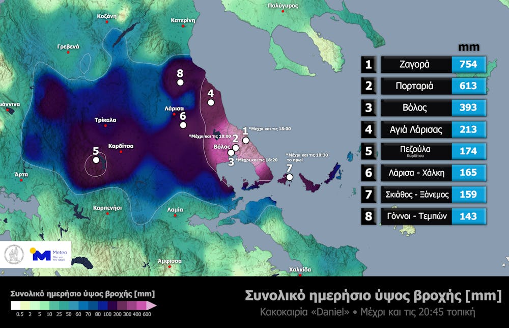
Storm Daniel landed on the Libyan coastal town of Toukrah in the early hours of September 10 and started moving east. Soon the wind was rising and heavy rain falling, forcing people to stay indoors. By afternoon the rain was clearly out of the ordinary.
Albaydah city on the coast would receive 80% of its annual rain before midnight, according to records from a local weather station that we have accessed. In less than 24 hours, thousands of people were dead, hundreds of thousands were missing, and towns and villages across Jebel Akhdar (the Green Mountain) in north-eastern Libya resembled a Hollywood disaster movie.
Storm Daniel was a Mediterranean cyclone or hurricane (a so-called medicane) which struck Greece, Bulgaria, Libya, Egypt and Turkey over the course of a week. Medicanes are not rare. Such large storms happen in this part of the world every few years. But Daniel has proved to be the deadliest.
At the time of writing, the World Health Organization estimates that at least 3,958 people have died across Libya as a result of the floods, with more than 9,000 people still missing.
Daniel was not an exceptionally big storm though. The medicane with the highest wind speeds was medicane Ianos in September 2020, which killed around four people and caused more than €224 million (£193 million) of damage. So what made Storm Daniel different?
Less frequent, but stronger
Like tropical cyclones, medicanes form in hot conditions at the end of summer. Most medicanes form to the west of the islands of Corsica and Sardinia. As they tend to strike the same regions each time, the people living in the western Mediterranean, southern Italy and western Greece, have built structures to deal with these storms and the occasional downpours they bring.
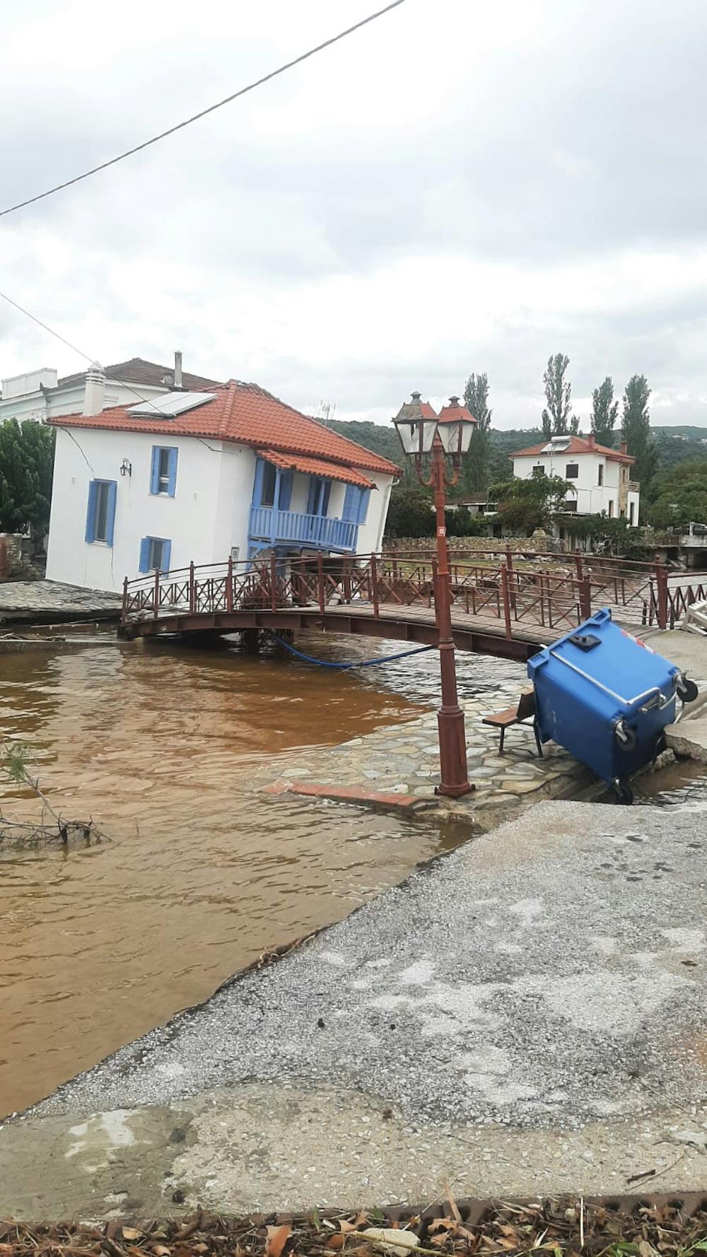
Daniel formed relatively far to the east and struck north-eastern Libya, which is rare. Dozens of people were killed in communities across Cyrenaica, the eastern portion of the country.
In the mountain gorge above the city of Derna, two dams failed in the middle of the night. Thousands of people, most of whom were asleep, are thought to have perished when the wave of water and debris swept down to the coast, destroying a quarter of the city.

Google Earth/Holly Squire, CC BY
Since medicanes are formed in part by excess heat, events like this are highly sensitive to climate change. A rapid attribution study suggested greenhouse gas emissions made Daniel 50 times more likely.
Despite this, the sixth assessment report from the UN Intergovernmental Panel on Climate Change (IPCC) concluded that medicanes are becoming less frequent but larger. Storm Daniel suggests where medicanes form and make landfall might be more important than their frequency and size.
So does Libya need to brace itself for more of these events in the future than it has in the past, even if they affect the western Mediterranean less often?
Clues from the past
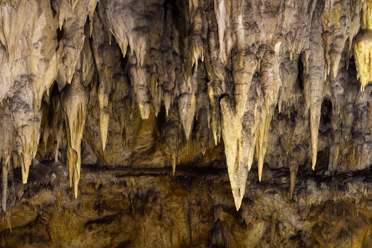
An important clue might lie deep underground, inside caves within north-eastern Libya. Although the caves are often dry today, they contain stalagmites which formed when rain passed through the soil, into the rock and dripped into the cave below thousands of years ago.
These rock formations attest to times in the past when this region was considerably wetter. The caves in Libya – and in Tunisia and Egypt too – form these stalagmites when the global climate is warm.
These bygone warm periods are not quite the same as the warm periods IPCC forecasts suggest modern climate change will usher in. But the way a hot world, a relatively ice-free Europe and North America and a wet northern Africa have regularly coincided in the past is striking. Striking and difficult to understand.
InFocus.ee/Shutterstock
That’s because the experiments that suggest medicanes will become less frequent as the climate warms belong to a pattern described by IPCC climate assessments, in which wet parts of the world are expected to get wetter and dry parts drier. So it is hard to understand why stalagmites tell us warmer periods in the past involved wetter conditions across the northern margin of the Sahara – one of the driest regions on Earth.
Fortunately, scientists can learn more from the way stalagmites sometimes grow imperfectly, leaving tiny blobs of water trapped between the crystals.
The stalagmite we recovered from Susah Cave on the outskirts of Libya’s Susah city, which was severely damaged in the storm, had quite a lot of water in it from wet periods dating to 70,000 to 30,000 years ago. The oxygen and hydrogen isotopes in this water are suggestive of rain drawn from the Mediterranean. This could indicate more medicanes were hitting the Libyan coast then.
Our finding that more rain was falling above Susah Cave during warm periods suggests we should get more storms hitting eastern Libya as the climate warms. This is not quite what the IPCC forecasts, with their prediction of fewer but larger storms, show.
But storm strength is measured in wind speed, not rainfall. The caves could well be recording an important detail of past storminess which we’re not yet able to forecast.
Are stalagmites warning us that North Africa must prepare for future medicanes shifting further east? Our ongoing research aims to answer that question.
The pattern of ancient desert margins receiving more rain during warm periods despite the “dry gets drier” pattern of global climate models is not unique to northern Africa but found around the world. Over millions of years, globally warm periods almost always correspond with smaller deserts in Africa, Arabia, Asia and Australia.
This “dryland climate paradox” is important to unravel. Understanding the differences between climate models and studies of ancient rain will be key to navigating the future as safely as possible.

Don’t have time to read about climate change as much as you’d like?
Get a weekly roundup in your inbox instead. Every Wednesday, The Conversation’s environment editor writes Imagine, a short email that goes a little deeper into just one climate issue. Join the 20,000+ readers who’ve subscribed so far.![]()
Mike Rogerson, Senior Lecturer in Earth System Science, Northumbria University, Newcastle; Belkasem Alkaryani, Lecturer in Geology, University of Tobruk, and Mahjoor Lone, Postdoctoral Research Associate in Palaeoclimatology, Northumbria University, Newcastle
This article is republished from The Conversation under a Creative Commons license. Read the original article.